http://adsabs.harvard.edu/abs/1993GeoRL..20.2571R
http://pubs.usgs.gov/fs/1997/fs113-97/
http://www.absoluteastronomy.com/topics/Mount_Pinatubo
Sunday, March 29, 2009
Questions
1.Which islands is Pinatubo located on?
2. When was Pinatubo's most famous eruption?
3. What were the hazards on Pinatubo? (lava flow)
4. How tall was Pinatubo before and after its most famous eruption?
5. What were the effects of the atmosphere after the most famous eruption?
2. When was Pinatubo's most famous eruption?
3. What were the hazards on Pinatubo? (lava flow)
4. How tall was Pinatubo before and after its most famous eruption?
5. What were the effects of the atmosphere after the most famous eruption?
Environmental Dangers/Benefits
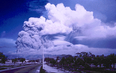
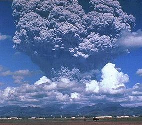
After the eruption in 1991 from Mt. Pinatubo, there were some noticable effects. There was more than a 4 mm think blanket of ash covering the city near the volcano, bringing darkness to the city for several hours. The airports were closed for days. The skies during sunsets for a couple of days after seemed to be more red then usual.
Eruption Style
Pinatubo is an explosive volcano. It has a high viscosity level. Mt. Pinatubo also has a pyroclastic flow, which means the lava (containing hot gas and rock) is fast moving.
Volcano Shape
Mount Pinatubo is a Stratovolcano and has a 1,745 meter peak, but after the eruption in 1991, it lowered from 1745 to 1486 m. Mt. Pinatubo has a crest of a 3 kilometer diameter dacite dome formed during an earlier eruption of 1991. Since Mt. Pinatubo is a composite volcano, it has steep sides. Mt. Pinatubo has a 1.5 kilometer long line of vents high on the volcano near the north flank of the summit dome.
Friday, March 27, 2009
Eruption History
Pinatubo has had over 40 eruptions since 1616. Its most recent eruption was in Febuary 1993. But the one eruption that no one will forget is the eruption in 1991 June 15. This eruption was the second largest in the 20th century! It had an enormous cloud of volcanic ash that rose as high as 22 miles into the air and grew to more than 300 miles across. It seemed to durn day into night. Up to 800 people were killed and more than 1,000,000 became homeless after the climax of the eruption, which lasted about 9-10 hours.
Geologic Location
Pinatubo is located on the islands of Luzon, an intersection of the Philippeans and the provinces of Zambales, Tarlac, and Panpanga. It is also located in the Cabusilan Mountain range.
Subscribe to:
Posts (Atom)


